
Winter is Coming: Chilly day for Sydney, rain pelts eastern seaboard
Just as we forecast yesterday, a coastal trough has deepened along the NSW and southeast Qld coasts as a low in the Coral Sea continues to inch closer to Qld.
The trough has brought some interesting weather to NSW in the past 36 hours or so, particularly along the coastal fringe, giving those New South Welshmen a “Stark” Game of Thrones reminder: winter is coming.
Gusty southerly winds brought the wind chill to Sydney today, with the city feeling no warmer than about 16°C. Significant wind gusts of 89km/h, 78km/h, and 72km/h were recorded at Wattamolla, Port Botany and Kurnell respectively between midday and 1:30pm, making Saturday lunch a very chilly and blustery affair for Sydneysiders.
Meanwhile, daily rainfall observations to 9am today revealed some very wet conditions for parts of the Hunter region. Norah Head and Toukley on the Central Coast received quite the drenching, with daily totals of 121mm and 97mm to 9am respectively, with much of this rain falling between midnight and 4:30am. Other notable rainfall totals include 67mm at Hamlyn Terrace, 59mm at Wyee, and 50mm at Bateau Bay.
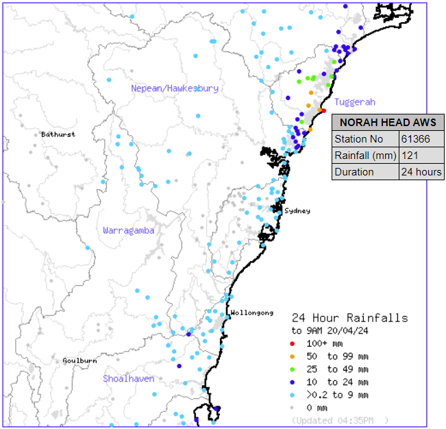
Image: 24 hour rainfall to 9am Saturday 20th April, 2024. Credit: Australian Government Bureau of Meteorology
Since 9am, the heaviest rain in NSW seems to have shifted just further north. Nords Wharf, situated less than 20km north-northwest of Norah Head and Toukley, had seen 61mm fall in the area by 4:30 this afternoon. Eleebana, about 15km southwest of Newcastle has received 38mm so far.
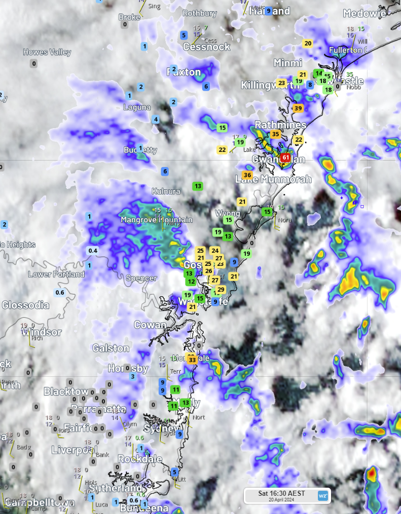 Image: Rain radar between Bundeena in Sydney’s south and Medowie in Newcastle’s north today, with rain gauge observations since 9am this morning
Further north, the coastal trough has brought persistent rain and showers to Qld, particularly around the Sunshine Coast. In the 24 hours to 9am, two different rain gauges in Pacific Haven recorded 86mm and 73mm of rain. Nearby Cherwell saw 56mm fall in its railway bridge rain gauge.
In the hours since 9am, a number of locations between Maroochydore and Noosa have received at least 50mm of rain. At 4:30 this afternoon, Doonan Creek had seen 89m fall in its gauge, with another 57mm falling over the creek’s upper reaches. Close by, Coolum West and Yandina Creek had received rainfall of 85mm and 72mm respectively. The town of Eumundi received 55mm while nearby Ball Lookout copped just a smidge more, registering 62mm in the gauge. Meanwhile, Tewantin and Mount Tinbeerwah have received 55mm and 54mm respectively.
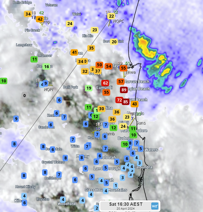
Image: Rain radar over Qld’s Sunshine Coast today, with rain gauge observations since 9am this morning
Areas further inland haven’t escaped the rain, though. Boondooma has seen the most notable rainfall so far, with 70mm in the gauge since 9am. Numerous locations in the area between Chinchilla, Dalby, Kingaroy and Gayndah have seen 30-50mm of rainfall already today.
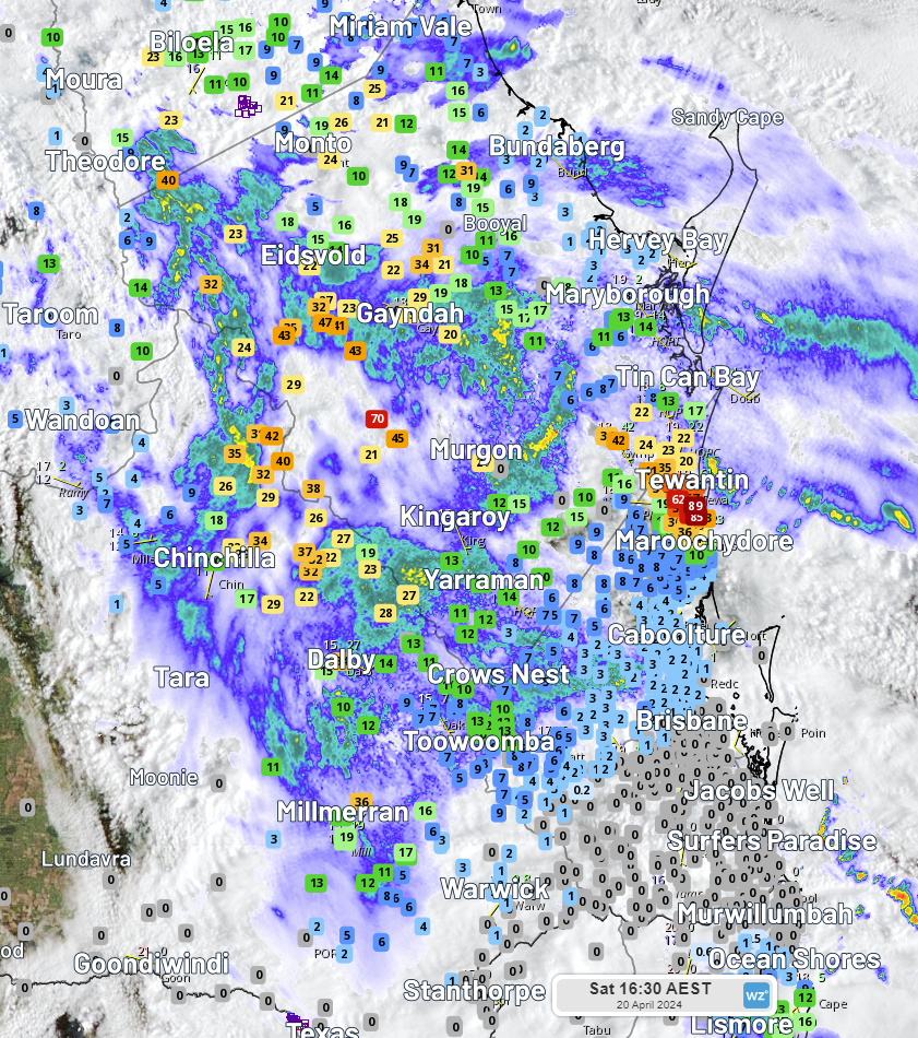 Image: Rain radar over Qld’s southeast today, with rain gauge observations since 9am this morning
With showers continuing to fall over the NSW coastal fringe and in Qld’s southeast quadrant, we can expect to see those rainfall totals increase in the coming hours.